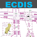
Electronic Chart Display Apps
Electronic chart display in name
Electronic chart display in description
Professional marine navigation used to require an expensive GPS plotter. Now, same technology used in merchant shipping is available for the iPhone.
Seapilot lets you navigate like a pro...
Welcome to the all-new App from Transas – the pioneer of modern marine navigation.
Transas manufactures the world’s number one Electronic Chart Display and Information System (ECDIS)....
Professional marine navigation used to require an expensive GPS plotter. Now, same technology used in merchant shipping is available for the iPad.
Seapilot lets you navigate like a pro...
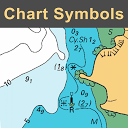
CHART SYMBOLS & ABBREVIATIONSSYMBOLS USED ON NAUTICAL CHARTS SPECIFIED BY THE INTERNATIONAL HYDROGRAPHIC ORGANIZATION (IHO), PLUS INTERNATIONAL ABBREVIATIONS AND SUPPLEMENTARY NATIONAL SYMBOLS...
SYMBOLS USED ON NAUTICAL CHARTS SPECIFIED BY THE INTERNATIONAL HYDROGRAPHIC ORGANIZATION (IHO), PLUS INTERNATIONAL ABBREVIATIONS AND SUPPLEMENTARY NATIONAL SYMBOLS USED BY THE U.S. AND U.K....
Professional marine navigation used to require an expensive GPS plotter. Now, same technology used in merchant shipping is available for Windows.
Seapilot lets you navigate like a pro...
Available Chart Folios cover coastal and offshore waters of North America, Latin and South America, Europe, Africa, Middle East, Far East, Asia, Australia & New Zealand.
iSailor is an...
“Download any FlytoMap application for Free! By purchasing FlytoMap All-in-One App.”
!! Watch "Flytomap GPS" app video on www.appreview.com and www.youtube.com !!
FlytoMap...
“Download any FlytoMap application for Free! By purchasing FlytoMap All-in-One App”
!! Watch "Flytomap GPS" app video on www.appreview.com and www.youtube.com !!
FlytoMap provides...
Suitable for offshore and coastal navigation, QuickCharts Aus/NZ is a fully featured GPS marine plotter complete with planning charts for Australia and NZ. The full folio of detailed charts are...